
Walk an Alton Street by Address
An address search works best as a chain, not as one result. Madison County's assessment roll can associate a site address with an owner label and parcel identification number, or PIN. The GIS map then places that parcel beside the rest of the street. Recorder documents can date transfers and other land interests. A voter lookup or an old directory may add a resident clue, but neither should be used to turn a whole block into a personal roster. Keep the source date with every name because Alton ownership, occupancy, and mailing details can change at different times.
- Enter a house-number range, street name, and Alton in the DEVNET property search. Save the site address and PIN.
- Open the same PIN in the Madison County GIS Viewer. Compare the parcel shape, address fields, and nearby lots.
- Check an individual registration only through the county voter search and follow its limits. Do not scrape a street list.
- Use the PIN, owner name, or document reference in the Recorder's land-record routes. Read the actual instrument before drawing a conclusion.
- For an older household, ask Hayner staff which directory volume covers the year and whether that volume has a street-order section.
The result is a set of dated facts. It may identify a legal owner, a tax mailing contact, or a person listed at an address in a certain year. It does not prove that every named person lived there at the same time.
Search Alton Street Directory Fields
DEVNET separates the parcel's physical location from the address used for tax mail. For a street-wide view, start with one main criterion and add only enough detail to control the results. A low and high house number can limit a long street. The site also has a separate Mobile Home Search tab, so its records should not be mixed with land parcels until the record type is checked.
| Portal field | How to use it | Key caution |
|---|---|---|
| House Number Low / High | Set an address range along one Alton street | Both fields are optional |
| Street Name and City | Search the site, or situs, location | Try exact suffix and direction variants |
| Parcel Number | Open one known parcel | The hint describes a 15 to 18 digit format |
| Owner Name | Find parcels under one owner label | An owner is not proof of occupancy |
| Mailing Address / City / State / ZIP | Find where owner mail is sent | This is separate from the site address |
| Sale, document, class, land-use and tax fields | Narrow a known record set | Dynamic choices and year controls do not prove full historical coverage |
The portal displayed a current data update on August 23, 2026, which is a freshness marker rather than a promise about older years. Its own guidance favors one chief criterion. Search results still need review for split parcels, units, duplicated owner labels, and street suffixes.
Alton Situs and Mailing Addresses
A situs address is the physical location of the parcel. Madison County's portal represents it with house number, street name, and city. The owner mailing address is where the tax bill or other owner mail goes. It can be outside Alton because the parcel is held by an estate, trust, company, or owner who receives mail elsewhere. That difference is one of the most important limits in a street directory.
- Parcel
- A mapped unit of land identified by a county PIN.
- Situs address
- The physical street location assigned to the parcel.
- Plat
- A recorded map that shows lots, blocks, boundaries, or a subdivision.
- Criss-cross directory
- A directory arranged by street and number rather than only by a person's surname. Hayner has not confirmed that every Alton volume includes one.
When the two addresses differ, preserve both labels. A mailing address is useful for interpreting the tax record, but it should never be silently substituted for the Alton site address or treated as a resident's location.
Map Alton Parcels Along Streets
The county GIS supports exact searches for a dashed PIN or an undashed county PIN. It also offers an owner-last-name contains search and spatial drawing by point, line, extent, or polygon. Those tools help distinguish the parcel at one house number from the lots around it. Map layers include parcels, addresses, roads, buildings, rail lines, water, district boundaries, and several imagery years.
The public CCAO parcel-owner layer description lists site number, street parts, city, ZIP, owner name and mailing fields, square feet, acres, PIN, and geometry. It does not provide a full tax card, sale price, assessment value, or proof of occupancy.
The source screen for the parcel-owner fields shows exactly why map results need a second record.
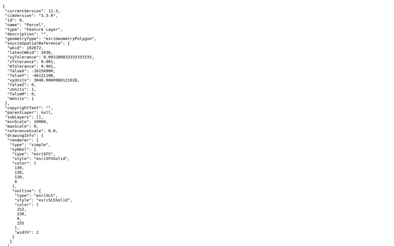
A live Alton parcel sample also demonstrates the separation of PIN, site fields, owner fields, acreage, and mailing data.
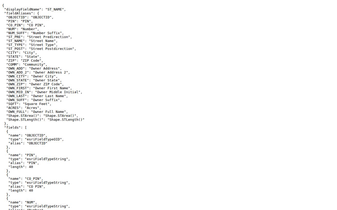
The sample proves what the layer returns, not who currently lives at that parcel. The GIS disclaimer also says the map is informational and not a survey or official copy.
Alton Records Indexed by Street
Different custodians answer different address questions. Madison County holds assessment, parcel, deed, and election records. Alton handles code enforcement, building and zoning work, address-number assignments for new construction, and municipal records requests. Hayner Public Library supplies the older directory and map bridge. No one source is a complete roll of residents.
| Record Set | Keeper | What It Shows | Access |
|---|---|---|---|
| Assessment roll | Madison County CCAO | PIN, owner label, site and mailing address, tax context | Free DEVNET portal |
| GIS parcel map | Madison County GIS | Parcel shape, nearby lots, owner and address fields | Free viewer and layer |
| Deeds, plats, liens and releases | Madison County Recorder | Parties, instrument, date, legal description and references | Tapestry, Laredo, or office copy |
| Permits and code records | Alton Code Enforcement | Address assignments, permits, inspections, zoning and citations | Department or FOIA request; no historical index found |
| Historical directories and maps | Hayner and public archives | Dated name/address clues and built context | Library, scans, microfilm, or archive |
| Individual voter lookup | County and state election offices | Permitted registration verification | Restricted by Illinois law; not a block roster |
The PIN links the roll to the map and helps bridge a modern address to deeds and plats. A street string can change, while a legal description or recorded reference may survive that change. Use the city department request route when the public pages describe a permit function but provide no result index.
Follow Alton Deeds by Parcel
Madison County land records begin in 1812, but the Recorder does not state how far back its online search runs. Public web access goes through Tapestry, while Laredo is a subscription route. An office or reference-number copy request is the fallback for records that cannot be reached online. The Recorder records the documents but explicitly does not perform title searches for the public.
The Recorder's document guidance shows why a street search must preserve instrument type and parcel format.
Start with the present owner and current deed. A grantor transfers an interest; a grantee receives it. Note the document number, book and page, legal description, and references to earlier instruments. Then search the seller as a prior grantee. Mortgages, releases, easements, and liens may explain the record trail, but they are not all changes of ownership.
Can a street address alone prove the chain? No. Treat it as an index clue. The PIN, legal description, plat, and recorded references provide the stronger bridge when Alton street text or numbering differs across eras.
Alton Permits and Street Names
Alton Code Enforcement assigns address numbers for new construction and handles permits, inspections, zoning, ordinance citations, and property-maintenance work. Its public page did not reveal a historical address-results database. Ask the department for the relevant record, or use the city's FOIA route when a public record is not otherwise posted. Exempt or private details may still be withheld.
The city's GIS mapping guidance explains the planning and code context for its maps.
Alton's code library and ward material can help when an older street label will not match the current county map. The riverfront, Upper Alton and Lower Alton labels, alleys, plats, and formal city boundaries add more chances for a mismatch. Preserve the old wording beside the modern normalized address instead of overwriting it.
Older Alton Streets in Context
The Hayner Genealogy and Local History Library holds Alton city directories beginning in 1858, though the late nineteenth-century-to-present run is incomplete. Some material is digitized, while other volumes require library help. A reverse or criss-cross section would arrange entries by street, but its availability has not been confirmed volume by volume. Inspect the title page, geographic scope, and front matter before promising an address-first search.
For the built setting, the Library of Congress holds a 14-sheet Alton Sanborn set from 1892, and the University of Illinois holds 1926 insurance maps with 82 leaves plus three unnumbered leaves. These maps show lots, building form, use, and street context. They do not name every household. Hayner's Alton Property Research File, plats, atlases, census indexes, and newspapers can then test a directory clue.
For a full account of the historical shelf, use the Alton city directory collections. The modern street directory remains focused on current address and parcel evidence.
Note: A missing directory year or unconfirmed reverse section is a collection gap, not evidence that an Alton household was absent.
Limits of an Alton Street Directory
A property owner is not always the current occupant. Assessment and GIS records do not promise a full household list, and a separate mailing field may identify an address outside Alton. Driver records, utility customer information, private delivery data, and protected voter addresses are not ordinary public street-directory sources. Illinois FOIA exemptions can also remove personal or safety-sensitive details from city and police records.
Illinois' Address Confidentiality Program can provide a substitute address to qualifying survivors. A public search may therefore stop for a sound legal or safety reason. Use official individual lookups within their stated purpose, and do not attempt to rebuild hidden locations from other data.
Lawful use. Use Alton address records only for lawful personal, family-history, property, or civic research. Never use them to stalk, harass, intimidate, or harm anyone.
A careful result states what each custodian actually shows: owner, mailing contact, parcel, recorded party, or dated directory entry. It does not relabel those fields as current residents.